EVIDENCE LIBRARY
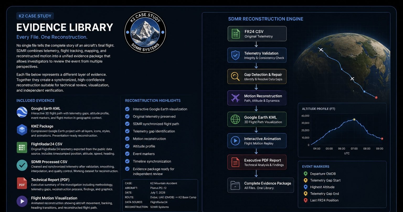
The SDMR Evidence Library organizes every file used during a reconstruction into a single, traceable workflow. Rather than presenting isolated documents, each file represents one stage of the reconstruction process—from raw telemetry to the final technical report.
Ever dataset can be reviewed independently while remaining connected to the complete reconstruction, allowing investigators, engineers, and analysts to follow the evidence from its original source through validation, visualization, and final conclusions.
Each evidence package contains standardized file formats for technical review, independent verification, and long-term archival.
CSV Flight Data
Dataset Summary
Format: CSV (Comma-Separated Values)
Category: Original Flight Telemetry
Source: FlightRadar24
Compatibility: Microsoft Excel • Google Sheets • MATLAB • Python • GIS Software
Data Type: Raw Telemetry Dataset
Records: Original Flight Tracking Records
Coordinate System: WGS-84
Time Standard: UTC
Status: Unmodified Source Data
Evidence Summary
Purpose
Provides the original aircraft telemetry exactly as recorded by FlightRadar24. This dataset serves as the foundation for SDMR analysis, allowing investigators to verify the source data, identify telemetry gaps, compare reconstructed results, and maintain an auditable chain of evidence throughout the investigation.
Primary Dataset Fields
- UTC Timestamp
- Latitude
- Longitude
- Pressure Altitude
- Ground Speed
- Heading (Track)
- Vertical Speed (when available)
- Aircraft Position
- Flight Status
Used By
✓ SDMR Reconstruction Engine
✓ Processed CSV Generation
✓ Google Earth KML
✓ KMZ Flight Animation
✓ Technical Report
✓ Independent Verification
The Raw Flight Data Behind the Reconstruction
A CSV (Comma-Separated Values) file is a universal data format that works much like a Microsoft Excel spreadsheet. Instead of formulas or graphics, it stores rows and columns of structured information that can be opened in Excel, Google Sheets, or imported into engineering and aviation software.
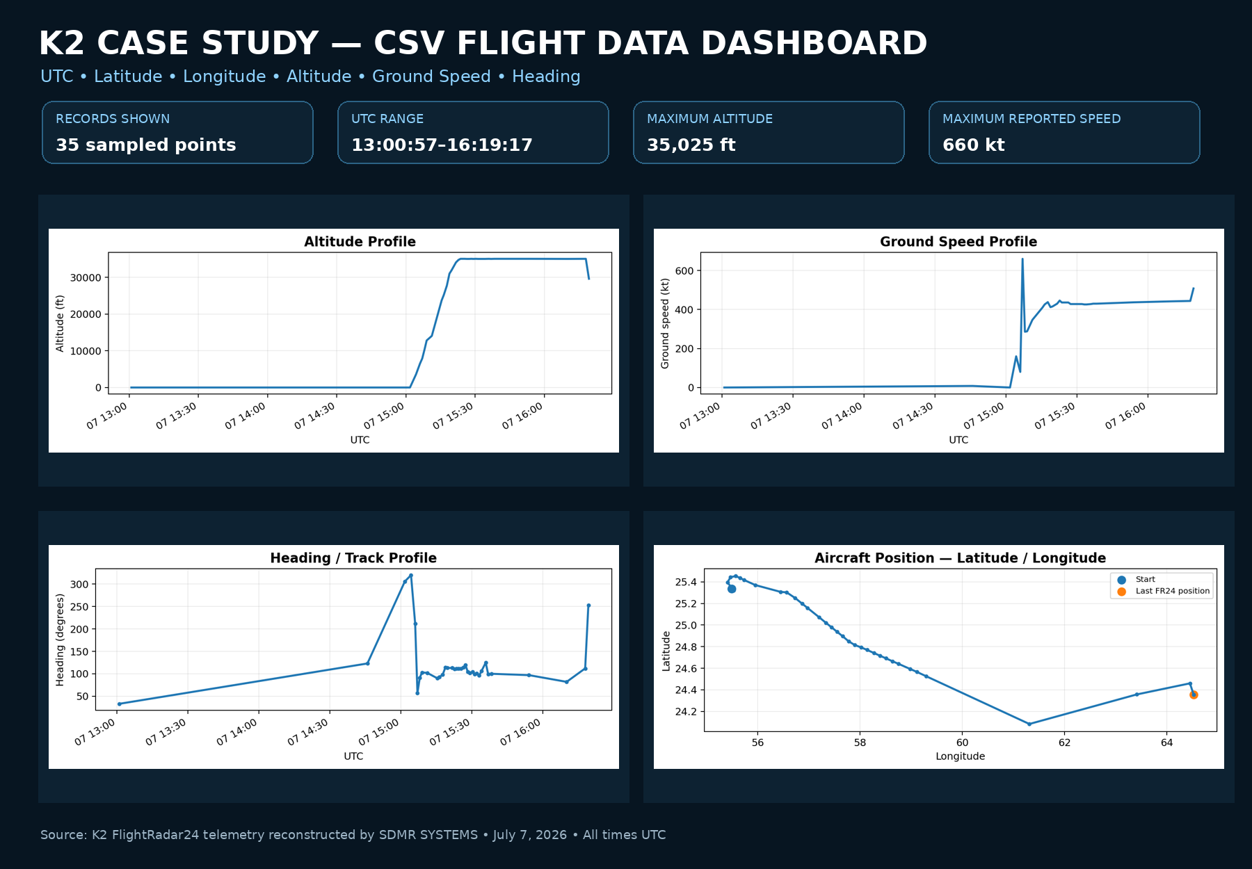
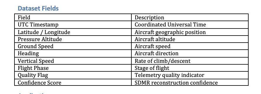
For the K2 Case Study, the CSV contains the original FlightRadar24 telemetry used during the SDMR reconstruction. Each row represents a recorded moment in the flight and includes information such as:
- UTC Timestamp
- Latitude & Longitude
- Altitude
- Ground Speed
- Heading
- Aircraft Position
This dataset serves as the foundation for the reconstruction, allowing SDMR to analyze the aircraft’s movement, identify telemetry gaps, validate the recorded flight path, and generate synchronized visualizations including KML, KMZ, and animated flight replays.
Evidence Summary
Purpose
Provides the original aircraft telemetry exactly as recorded by FlightRadar24. This dataset serves as the foundation for SDMR analysis, allowing investigators to verify the source data, identify telemetry gaps, compare reconstructed results, and maintain an auditable chain of evidence throughout the investigation.
Primary Dataset Fields
- UTC Timestamp
- Latitude
- Longitude
- Pressure Altitude
- Ground Speed
- Heading (Track)
- Vertical Speed (when available)
- Aircraft Position
- Flight Status
Used By
✓ SDMR Reconstruction Engine
✓ Processed CSV Generation
✓ Google Earth KML
✓ KMZ Flight Animation
✓ Technical Report
✓ Independent Verification
PROCESSED DATA
Dataset Summary
Format: CSV (Comma-Separated Values)
Category: Validated Flight Dataset
Source: SDMR Reconstruction Engine
Compatibility: Excel • Google Sheets • MATLAB • Python • GIS Software
Type: Processed CSV
Version: SDMR v1.0
Records: Validated Flight Data
Coordinate: WGS-84
Time Format: UTC
Status: Verified
Evidence Summary
Purpose
Provides the validated flight dataset used to reconstruct aircraft motion, verify telemetry, and generate synchronized visualizations.
Used By
✓ KML Flight Path
✓ KMZ Animation
✓ Technical Report
✓ Motion Analysis
✓ Timeline Reconstruction
This immediately tells visitors how the Processed CSV connects to everything else in the evidence package.
The Validated Flight Data Behind the Reconstruction
The Processed CSV is the validated dataset generated by the SDMR reconstruction process. Unlike the original FlightRadar24 telemetry, this file has been synchronized, verified, and organized into a consistent timeline for analysis and visualization.
Each row represents a reconstructed point in the aircraft’s flight and combines the available telemetry into a standardized format that can be opened in Microsoft Excel, Google Sheets, or imported into engineering, GIS, and aviation software.
ApplicationsSDMR_Flight_Statistics.csveline Analysis
- Motion Validation
- Engineering Review
- Independent Verification
Suggested CSV Downloads:
KML DATA
Dataset Summary
Format: KML (Keyhole Markup Language)
Category: Interactive Flight Visualization
Source: SDMR Reconstruction Engine
Compatibility:
Google Earth Pro • Google Earth Web • ArcGIS • QGIS • GIS Software
Type: Interactive Flight Path
Version: SDMR v1.0
Coordinate System: WGS-84
Altitude Reference: Mean Sea Level (MSL)
Time Format: UTC
Status: Verified Reconstruction
Evidence Summary
Purpose
Provides an interactive three-dimensional reconstruction of the aircraft’s flight path, allowing investigators to examine aircraft position, altitude, heading, telemetry events, and reconstructed motion directly within Google Earth.
Applications
• Interactive flight replay
• Telemetry validation
• Event marker visualization
• Altitude profile review
• Flight path measurements
• Geographic analysis
Suggested KML Downloads
• Reconstructed Flight Path
• Event Markers
• Altitude Profile
• Telemetry Gap Markers
• Final Reconstruction
The Interactive Flight Path Behind the Reconstruction
The KML (Keyhole Markup Language) file is the primary visualization used by SDMR SYSTEMS to display reconstructed aircraft movement in Google Earth.
Unlike a spreadsheet, a KML file combines geographic coordinates, altitude, timestamps, and annotations into an interactive three-dimensional flight path that can be explored from any angle.
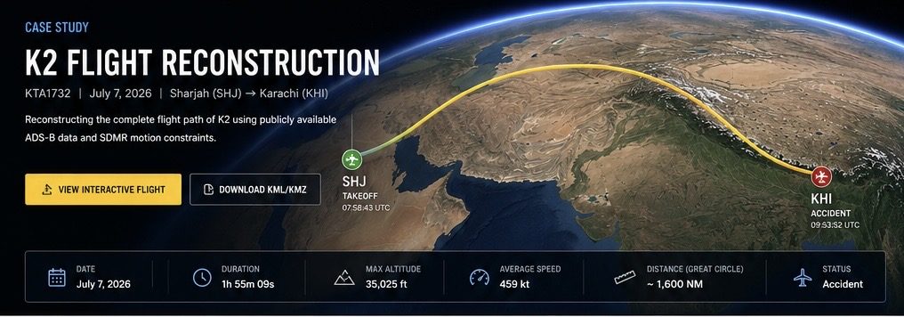
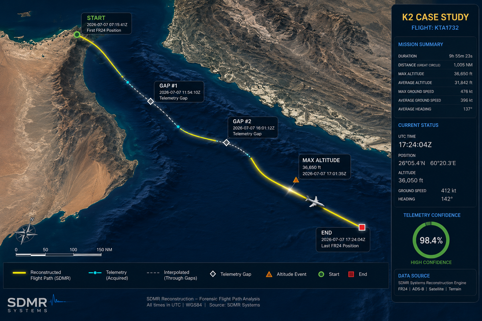
For the K2 Case Study, the KML represents the reconstructed aircraft trajectory generated from validated telemetry and synchronized flight data. It allows investigators to examine the aircraft’s movement, altitude profile, heading changes, telemetry gaps, and significant events throughout the flight.
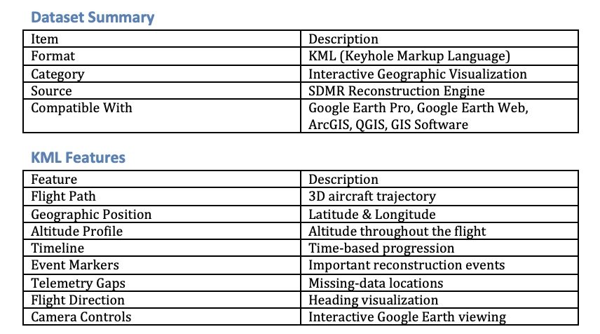
Evidence SummaryK2_Final_Reconstruction.kmlactive 3D visualization of the reconstructed flight, allowing investigators to review aircraft movement within its geographic environment.
✓ Flight Path Visualization
✓ Motion Reconstruction
✓ Timeline Analysis
✓ Technical Reports
✓ Engineering Review
✓ Independent Verification
Used By
- Google Earth Pro
- Technical Reports
- Motion Reconstruction
- Timeline Analysis
- Independent Verification
- Presentation Graphics
KMZ DATA
Interactive Flight Reconstruction (KMZ)
Dataset Summary
Format:
KMZ (Compressed Keyhole Markup Language)
Category:
Interactive 3D Reconstruction
Source:
SDMR Reconstruction Engine
Compatible With:
Google Earth Pro
Google Earth Web
ArcGIS
QGIS
GIS Software
Status: Verified Reconstruction
Evidence Summary
Purpose
Provides an interactive three-dimensional reconstruction of the aircraft’s flight path, allowing investigators to examine aircraft position, altitude, heading, telemetry events, and reconstructed motion directly within Google Earth.
Applications
• Interactive flight replay
• Telemetry validation
• Event marker visualization
• Altitude profile review
• Flight path measurements
• Geographic analysis
Suggested KML Downloads
• Reconstructed Flight Path
• Event Markers
• Altitude Profile
• Telemetry Gap Markers
• Final Reconstruction
The Interactive Flight Path Behind the Reconstruction
The KMZ (Keyhole Markup Language Zipped) file is the primary interactive visualization produced by the SDMR Reconstruction Engine. It combines the reconstructed flight path, event markers, altitude profile, and supporting datasets into a single compressed package for viewing in Google Earth.
Evidence SummaryK2_Final_Reconstruction.kmlactive 3D visualization of the reconstructed flight, allowing investigators to review aircraft movement within its geographic environment.
✓ Flight Path Visualization
✓ Motion Reconstruction
✓ Timeline Analysis
✓ Technical Reports
✓ Engineering Review
✓ Independent Verification
Used By
- Google Earth Pro
- Technical Reports
- Motion Reconstruction
- Timeline Analysis
- Independent Verification
- Presentation Graphics
EVIDENCE LIBRARY -
SDMR RECONSTRUCKTION ENGINE
CSV Flight Data
The Raw Flight Data Behind the Reconstruction
A CSV (Comma-Separated Values) file is a universal data format that works much like a Microsoft Excel spreadsheet. Instead of formulas or graphics, it stores rows and columns of structured information that can be opened in Excel, Google Sheets, or imported into engineering and aviation software.
For the K2 Case Study, the CSV contains the original FlightRadar24 telemetry used during the SDMR reconstruction. Each row represents a recorded moment in the flight and includes information such as:
- UTC Timestamp
- Latitude & Longitude
- Altitude
- Ground Speed
- Heading
- Aircraft Position
This dataset serves as the foundation for the reconstruction, allowing SDMR to analyze the aircraft’s movement, identify telemetry gaps, validate the recorded flight path, and generate synchronized visualizations including KML, KMZ, and animated flight replays.
Purpose: Original telemetry dataset used for analysis and independent verification.
For the best experience, download these resources for offline use. SDMR SYSTEMS uses common formats such as PDF, Microsoft Word, Microsoft Excel CSV, Google Earth KML
KML Flight Data
FLIGHT RECONSTRUCTION

February 2019 until Present
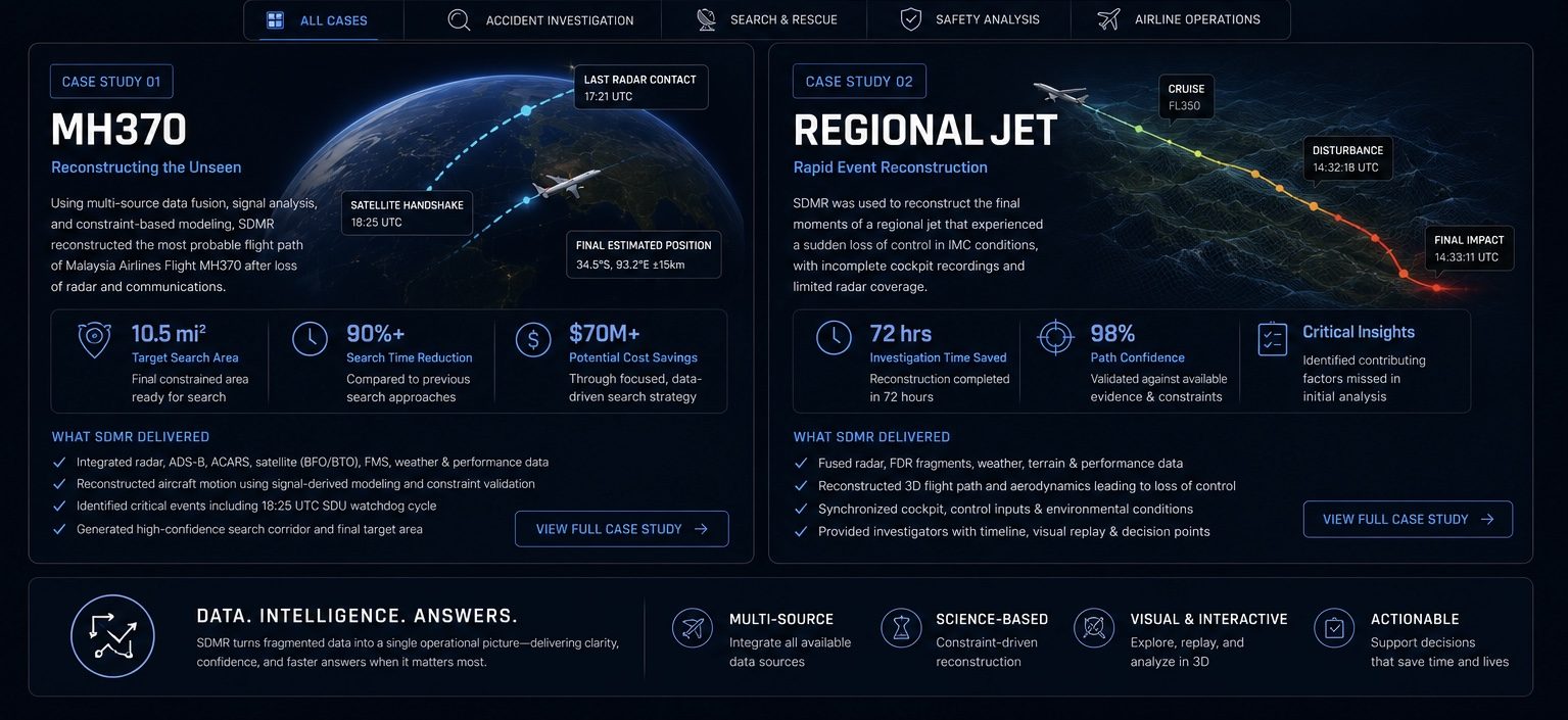
Flight reconstruction is the process of rebuilding an aircraft’s journey using information collected from many independent sources. Instead of relying on a single radar return, satellite message, or flight record, investigators compare navigation procedures, aircraft performance, communications, weather, maintenance records, and technical documentation to create a complete picture of what occurred.
SDMR brings these sources together into a single, connected framework. Each piece of evidence is synchronized, cross-referenced, and validated against every other source, allowing investigators to build a continuous timeline of events, identify inconsistencies, and reconstruct the aircraft’s most probable flight path with greater confidence. The result is a structured, transparent investigation where every conclusion can be traced back to the supporting evidence.
Tagline
Euismod condimentum dolor sit amet
Lorem ipsum dolor sit amet, consectetur adipiscing elit. Nulla euismod condimentum felis vitae efficitur. Sed vel dictum quam, at blandit leo.